Normet SmartScan® Align reshapes the documentation of sprayed concrete
 As you know the Normet SmartScan® system has been on the market for about two and a half years now and proven it’s worth as a fast and simple tool to help sprayer operators control the layer thickness efficiently and with full coverage of the tunnel surface. The optimized layer thickness ensures safety without accidental under-spraying, but also improves efficiency and lowers the carbon footprint by cutting down the excessive over-spraying.
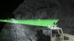
Since the launch of the system many users have seen the potential of Normet SmartScan® as an as-built documentation tool if georeferencing is added. Based on this we started developing the georeferencing feature and wanted it to follow the very simple and highly automated functionality of the basic system. The system we came up with is based on reflective surveyed targets on tunnel walls which an additional laser scanner on the sprayer picks up and then the system works out the georeferencing of the point clouds and layer thickness colour maps the SmartScan produces. The operator’s workflow during spraying process stays the same as before with only some seconds of time added to the scanning cycle.
The georeferencing solution SmartScan Align will turn our sprayers to digital near real time process optimization and documentation setups. The as-built documentation is still provided in digital point cloud format which has already consolidated it’s position as an industry standard and is widely compatible with BIM models and surveying software packages, but the real game changer here is that the surface and layer thickness mapping is ready before the sprayer is pulled out of the heading. We expect this to reconstitute the thinking of reporting and as-built documentations in tunnelling and mining.